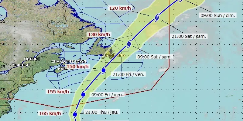
The expected track of hurricane Larry has shifted to the west, with the latest forecast suggesting the storm could make landfall in eastern Newfoundland early Saturday.
The Canadian Hurricane Centre in Halifax issued a tropical cyclone chart this morning that shows the centre of the storm crossing over the island’s Avalon Peninsula at 3 a.m. on Saturday. At that point, Larry’s maximum sustained winds are expected to be 140 kilometres per hour, a Category 1 hurricane.
As of the moment, Larry is generating sustained winds of 185 kilometres per hour, a Category 3 hurricane. As it scurries northward, Larry will grow to about ten times its current size as the ocean water cools. Warm water is the fuel needed for a hurricane to survive.
Athene Masson, a hurricane forecaster in Miami who did post-secondary studies at Memorial University, says Larry is similar to Igor in that it is maintaining hurricane status for such a long period of time but we can thank our lucky stars for another system pushing into Newfoundland from the west.
Masson says a low-pressure system from the other direction will pick up Larry and move it out of the region quickly.
The Avalon Peninsula will bear the brunt and keep in mind that the rain comes before the wind.
She wouldn’t be surprised to see 100 mm of rainfall but also cautions to be mindful of the surf and not to venture near the coastline because of large waves.
The latest full update from the CHC with details on Hurricane #Larry 🌀 are now posted at https://t.co/PdHWbeMHmw cane/statements_e.html . Information will be updated every 6 hours at this link with track https://t.co/URkX949IGp. #nlwx #nlstorm pic.twitter.com/pg2Llq1i7P
— ECCC Canadian Hurricane Centre (@ECCC_CHC) September 8, 2021
Path of Hurricane Larry Becoming More Clear - VOCM
Read More


No comments:
Post a Comment